|
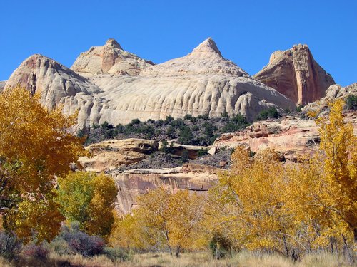
A bentonite hill, which is made up of ash layers from ancient volcanoes
at Capitol Reef National Park |
all photos by Olga Bonfiglio except those marked
Utah is no place for the faint of heart whether plant,
animal, or human. In this land of
weathered rock amid sagebrush, yucca, cactus, juniper, cottonwoods and pinyon
pine, travelers gain a new appreciation for wind and water’s role in shaping
the landscape.
The majestic landforms of the Colorado Plateau will set your
imagination on fire—along with the 100-degree dry heat—in Zion, Bryce Canyon
and Capitol Reef National Parks.
These parks offer visitors an uncanny beauty and an
experience of nature’s “sculptures” that result from tremendous geological
changes dating back 2 billion years ago—and counting.
Rivers, seas and desert winds have shaped this land and you
can witness the different geological eras at the canyons’ and cliffs’
outcroppings.
The Colorado Plateau is a 130,000 square-mile swath covering
the intersection of Utah, Colorado, New Mexico and Arizona. Sixty-five million years ago the region
experienced uplift, tilting, and erosion of rock layers to form the Grand
Staircase, a series of colorful cliffs stretching from the Grand Canyon to
Bryce Canyon and including the Waterpocket Fold in Capitol Reef.
But the landscape of the parks and surrounding areas, which
are not crowded at all, will look familiar.
Of course, this was the land of the cowboys that you saw in the
movies. Walk on the land and you hear
and feel the crunch of the scrubby plants underfoot, endless dust, the winding
paths around the sweet-smelling sagebrush and haunting rock formations that
used to be good hiding places for outlaws.
But the desolation and silence of the desert also allow you
to witness its majesty and enchantment as well as to feel an eerie connection
to the Western pioneers, Native Americans, and prehistoric peoples who once
settled or traversed this land. It’s
really much the same as they saw it.
The national parks in southern Utah preserve this natural
landscape for you and millions of visitors, as they have been doing for about
100 years.
Zion National Park
 |
| Observation Point -- photo by Zion National Park |
The area that became Zion National Park was largely ignored
until 1908 when Leo A. Snow, a U.S. deputy surveyor from St. George, Utah, did
a general land survey and suggested that the land here be set aside and
preserved as a sanctuary for wildlife and natural and cultural resources found
nowhere else on earth. In 1919 Zion
became a national park with the Kolob section added in 1937.
This place got its name, meaning “place of refuge,” from
Mormon pioneers who sought sanctuary after being kicked out of Illinois, Ohio
and Missouri because of their “strange” religious beliefs. The Children of Israel are an “Old Testament
people,” says author Wallace Stegner, “inheritors of the blessings of the tribe
of Joseph.” Inspired by their prophet,
Joseph Smith, and led by Brigham Young in 1846, they moved and settled in this
“land that nobody wanted.”
 |
| Zion National Park |
The biblical names in the park reflect the Mormon
influence: Court of the Patriarchs, the
grotto at Angels Landing, Watchman Trail, Mt. Carmel Highway. But whatever your religion, you’ll marvel at
the wondrously high cliffs and deep valleys which have been cut by the
slow-moving Virgin River—and God’s hand in nature.
A single road through Zion’s canyons takes you on numerous
switchbacks and a long dark tunnel through a mountain. You’ll see yellow, red, white and green
striped mesas (flat-topped mountain tops), long fingered rock formations,
summits, and cathedrals. Slickrock,
huge blocks of smooth-surfaced, flat sedimentary rock (sandstone, mudstone, and
siltstone), comprises the high cliffs and deliciously cool overhangs that
shield you from the hot sun. This rock
is so soft you can rub it off with your finger. Large, weather-beaten boulders will tickle your imagination into
seeing animal and human shapes.
 |
| Zion National Park |
Indeed, human habitation on the Colorado Plateau has been
sparse. The earliest records of human
life go back 10,000 years when the Paleo-Archaic Indians roamed this land. The Anasazi People, the first permanent
settlers here 2,000 years ago, lived in small, scattered farmsteads but left
around 1300. The land was not occupied
until the Paiute People came 800 years ago.
On July 24, 1847, Brigham Young and the Mormons arrived
To get an overview of the park, take the road leading
through it or the free shuttle that takes visitors on a 90-minute
scenic tour stopping at trailheads, the Museum of Human History, Zion
Lodge. The shuttle goes in some places
where cars may not go.
Bryce Canyon National Park
 |
| Hoodoos at Bryce Canyon |
In mountainous areas you generally look up at the
scenery. At Bryce Canyon, you look
down—at the hoodoos, those pillars of rock that look like whimsical earthen
obelisks.
Sculpted by wind and nightly freezing desert temperatures,
the hoodoos got their name from Native American lore where the coyote turned
the evil people to stone. The “painted”
pink, white and red (iron), purple (manganese), and white (limestone) “faces”
serve as evidence of the myth.
 |
| Hoodoo of Queen Victoria on the Queen's Way |
Geologists say that 10 million years ago forces within the
earth created and then moved the Table Cliffs and Papunsaugunt Plateaus. Ancient rivers carved the colorful Claron
limestones, sandstones and mudstones into thousands of spires, fins, pinnacles
and mazes, and exposed the edges of these blocks creating the Paria
Valley.
Walk the Queen’s Way and you instantly get an idea of how
the eroding winds work as you cover you eyes and close your mouth to protect
yourself against the swirling airborne sandstone.
Get tickets for a horse or mule ride through the canyon at
the park’s lodge or two-hour or half-day tours through the various levels of
the canyon floor and among these giant sand castles.
I only stopped at Bryce Canyon on the way from Zion to
Torrey, but you will want to spend more time at this incredible showcase.
 Grand Staircase/Escalante
If you haven’t already gotten a sense of gigantism in
southern Utah, you will if you take the blue highways from Zion to Bryce Canyon
to Capitol Reef National Park. Around
the town of Escalante, this 200-mile trek winds through country that either
looks like the Flintstone’s village or a huge rock garden.
Boulders mix sparingly with vegetation and the mesas
resemble altars to the gods. You’ll
suddenly notice that there are few traces of humanity in these parts except for
a single power line or the road you’re driving. You’ll feel humbled by your own smallness amid these open and
desolate spaces and realize that Western-style individualism has been greatly
mythologized. No one could have
survived these lands unless they worked together, which is what the Mormons
did.
 |
| Grand Staircase -- Escalante |
Construction engineers who built these winding roads over
immense expanses of sedimentary rock, must have marveled at these mountainous
scenes, too. (Some roads climb 300 feet
at 6- to 8-degree grades.) They have
left a few scenic turnouts for travelers to stop and gaze at the yellow rock
that looks like a moonscape with trees and sagebrush.
Huge stone piled onto stone offers a vista of endless
scenery, one view more beautiful and more magnificent than the other. Halfway to Torrey, you’ll see what look like
gray beehives. No, these landforms are
not the origin of the state’s nickname, the symbol of the industrious
Mormons. These landforms are part of
the Grand Staircase/Escalante, named after Fray Silvestre Velez de Escalante, a
Spanish priest who accompanied Fray Francisco Atanasia Dominguez. They traversed southwestern Utah in 1776
searching for a passable trail to Monterey, California.
 |
| Grand Staircase -- Escalante |
Drive further north and you see one more surprise: Dixie National Forest. This area features unusual green vegetation
nestled among the yellow rock mountains.
You’ll see ranches with wire fences for cows and horses as well as signs
for uniquely Western-style names: Hell’s
Backbone, Salt Gulch, Circle Cliffs, and Burr Trail.
Nearing the 9,400-foot summit, you pass pine, spruce,
Douglas fir and aspen trees and get an overview of the “staircase.” So much greenery after all that rocky
wilderness even inspires a few bicyclists to brave the steep heights.
Capitol Reef National Park
 |
| "Dome" formations look like U.S. Capitol Building -- photo by Planetware |
Capitol Reef allows you to interact with millions of years
of geologic history and thousands of years of human history at the same
time.
The 100-mile long Waterpocket Fold formed when the Pacific
Ocean plate bumped into the North American continent about 65 million years ago
and created the Rocky Mountains. About
200 million years ago, the ocean layed down red and later gray sediments.
Other remnants of geologic activity are the black boulders
scattered over the land 20 to 30 million years ago. They came from the lava flows of the volcanic Boulder Mountain 50
miles away. Glaciers later eroded
them.
Round holes of many sizes line the rock walls. This “honeycomb weathering” formed by the
circular motion of tidal flats, sometimes gouged out caves due to the uneven
density of the rock.
The park features layered multi-hued cliffs, soaring spires,
twisting canyons, graceful arches and stark monoliths that inspired the Native
Americans to call this area the “Land of the Sleeping Rainbow.” The white sandstone domes (prehistoric sand
dunes) resemble the dome of the Capitol Building in Washington. Hence, the park’s name
 |
| Temple of the Moon (L) and the Sun (R) in Cathedral Valley of Capitol Reef |
The geologic history of Capitol Reef provides an unforgettable
experience of the land. However, to
gather the unique spiritual quality of this place, take the unpaved road to
Cathedral Valley where you’ll find the Temples of the Sun and Moon. These stately, stone monoliths give you a
feeling of permanence in much the same way cathedrals do in a city. Their awesome power amid the dense quiet of
the desert puts you in an altered state of mind as you gaze on the dry and
dusty world around you. The bumpy road
to get there allows you to move only 20 miles an hour and requires a
high-clearance or a four-wheel-drive vehicle.
Tours on the road are available in Torrey.
Dinosaurs once roamed this area and you can easily find
traces of them in the gastropods scattered around the Morrison rock. Gastroliths are smooth, round rocks the
dinosaurs ingested and excreted much like the chickens do with their gizzard
stones.
You will find Devil’s toenails, too, which provide more
evidence of the ocean that once covered the land. The “toenails” are petrified seashells much like fossils only
without the rock around them. However,
park rangers ask that souvenir hunters pick up these geological gems only
outside the park. And there’s plenty of
them.
 |
| Pictographs at Capitol Reef National Park |
One exciting link to the human history at Capitol Reef is
through the petroglyphs (etched) and the pictographs (painted) on canyon
walls. They give you a glimpse of the
Fremont People who lived here from 700 to 1250 A.D. Their mainstay was bighorn sheep, which they proudly displayed
with trapezoid-like images of themselves.
The park provides free interpretive tours of this ancient artwork but
make friends with the locals who can take you to see other groups of them
outside the park.
“Hobbit Land” is another place outside the park that the
locals can show you. In sight of Boulder
Mountain, the largest flat-topped mountain in the United States, these
globular
red rocks are good for climbing for experts and novices alike. Moving
about them invites you to “commune”
with the land by becoming a part of it—literally. Wear your old
clothes, though, when you climb these rocks. The soft Entrada sandstone
that rubs off on
you is impossible to remove.
Capitol Reef also features a look into the Mormon culture
that was established in 1879 along the Fremont River (also called the Dirty
Devil). First known as Junction and
nicknamed “the Eden of Wayne County,” the Fruita settlement flourished through
irrigation of sorghum (for syrup and molasses), vegetables and alfalfa. The orchards which were famous a hundred
years ago still stand today with a variety of apples, apricots, peaches, pears,
plums, English and black walnuts and almonds.
Eight to 10 large families sustained this community until the late 1960s
when the Park Service purchased Fruita property.
Travelers can visit Fruita’s one-room schoolhouse, which
also served as a town hall and church from 1884 until 1941. In 1900 the public schools adopted the
building until it closed in 1941 due to lack of students.
If you go:
You can best get to Utah’s national parks by flying to Las
Vegas or Salt Lake City and renting a car.
Warning:
Drink
a lot of water, bring sun block and wear a hat. There is little cloud
cover in Utah, which provides protection from the hot sun.
The mornings and evenings are cool enough for a light jacket.
 Imagine seeing a man on a subway escalator accidentally drop a small wad of paper from his pocket and then pick it up.