The unbelievable natural scenes in the Outback were exciting discoveries--every time. They never failed at presenting the extraordinary beauty of the land. On our second day in the Outback we went to the glorious Simpson Gap and Standley Chasm to see the waterholes, flora, and rock formations.
Simpson's Gap
Simpsons Gap is a part of the
West MacDonnell Ranges in Australia's Northern Territory located 11 miles west from Alice Springs on the Larapinta Trail. It features towering cliffs, a waterhole, and an elaborate caste of wild plants and animals.
Known as Rungutjirpa to the Arrernte people who inhabited this area before the Europeans arrived, this was the mythological home of a group of giant goanna (right) ancestors and an important spiritual place. Several dreaming trails and stories are connected to this important spiritual site. Surveyor Gilbert Rotherdale McMinn discovered the Gap in 1871 while he was searching for a route for the Overland Telegraph Line.
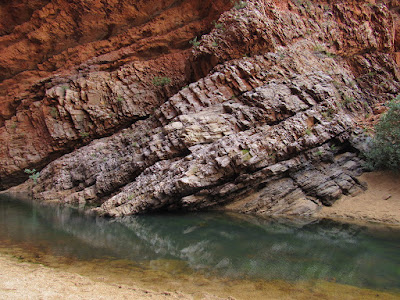
The ranges are composed of many rock types including red quartzite, granite, limestone, sandstone and silt stone. Some of the valleys of the range even contain fossil evidence of the shallow sea that once covered central Australia 800 million years ago. The tides and currents deposited a deep layer of quartz sand coated in iron oxide dust. This sand was buried by later deposits and then compressed into a very hard rock called quartzite.
 About 350-300 million years ago mountain uplift created the
MacDonnell Ranges whose highest peaks reached 30,000 feet. Since
that time, folding, faulting and erosion have shaped the range as these rocks show. The highest peak now is 7,000 feet. Gorges like Simpson's Gap were formed while powerful flood waters sculpted the rock.

The trees were intriguing in their colors, shapes, and poses.
The Gap is home to various plants and wildlife, including the black-footed rock-wallaby (right). It also has a permanent waterhole and vegetation typical of the MacDonnell Ranges with large stands of mulga trees (left) and over 40 rare plants.

Along the way
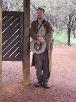
If we were looking for Aussie stereotypes, this park ranger fit the bill. After we descended our bus and as Callum, our tour guide, was giving us a brief orientation, this man approached us from out of nowhere. He seemed like someone from the past who had just appeared to us. The mystical Outback is full of surprises.
Cordelia, our bus driver, is originally from Milan, Italy. She moved to Australia about a year ago and is a bus driver and soon-to-be driver-guide. She seemed to adapt splendidly to Aussie life--and her English was impeccable with a signs of an Australian accent emerging. She could also wield that big bus around without a sweat. The Outback seems to bring out talents and strengths of character that might otherwise have remained hidden. She may have just found her place in the world at this time in her life.
Cordelia met us at the Alice Springs airport in her big Aussie hat, trail shirt and shorts, and hiking boots. She connected with us immediately and her beaming personality and warm greetings displayed the essence of hospitality.
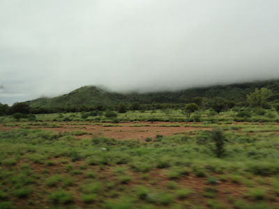
The fog makes this area truly mystical, and the Native Peoples believe that the Ancestral Beings remain at work in such landscapes. These beings solicit respect from Human Beings whose lives depend on and benefit from the Earth.
The variety of greens on the red soil and rock outcroppings make for an irresistible scenic view that truly inspires modern people just passing through as well the Aboriginal people who have lived here for thousands of years.

Before it was franchised in Australia, Burger King was called Hungry Jack. There is no escaping American fast food--even in the Outback.
Standley Chasm
In the beginning, Ancestral Beings created the landscape and its features. In their journeys they created the mountains, rivers, rock holes, gorges and culturally significant sites. Sometimes these Ancestors were traveling through, and sometimes they stayed. Their essence is living in the landscape still today.
Standley Chasm was named after Mrs. Ida Standley (1920-75) as a mark of respect for her work in education in the Alice Springs area. The Chasm's Aboriginal name is Angkerle Atwatye
The quartzite walls of the Chasm were formed by ancient seabeds 2.2 billion years ago, some of the earliest mineral formations on the planet. This marble-like quartzite is actually blue-grey in color but oxidation gives it the red surface. Its North-South orientation allows direct sunlight to enter the Chasm for only 90 minutes at midday by illuminating the walls with an impressive glow.
The wide variety of rocks
and minerals along the Chasm floor have been transported by water and
time through this constantly evolving riverbed. Underneath the rocky
surface the creek continues to flow, so that Standley Chasm is truly
"the place (Angkerle) where the water moves between (Atwatye)".


The hydrology of Angkerle Spring is a rare and special occurrence: an underground creek with a wide rainwater catchment AND multiple mountain spring aquifers that provide an easily accessible permanent open water supply. This spring is the source of survival for unique ecosystems and refuges, and it maintains its cultural importance for the region.
For these traditional desert peoples, this reliable waterhole is a very precious, significant place: it provides important cultural, spiritual and material resources--a fundamental requirement of the local flora and fauna for medicinal supplies and plant materials for making tools and structures.
 Annual rainfall is low and intermittent in the region (average 12 inches/year). When northern rains flood the higher plains of the Tanami Desert, the runoff pours through the West MacDonnell Ranges. Large volumes of fresh water rapidly flow down the rugged gullies, funneling through many vertical schist and gravel creek beds into shallow aquifers where it is stored, cooled, and protected from evaporation. Water converges at the junction of two major creeks at the back of the Chasm, passing through and surging into rapids down the creek bed, and sometimes through the car park itself!
A constant supply of ancient water seeps slowly through quartzite rock, maintains a reduced but constant supply in drought. This ancient source at "Angkerle" is one of eight permanent waterholes in the region responsible for maintaining life in the arid West MacDonnells bioregion.
Although small in appearance, this astonishing series of surface and underground springs can have an enormous output. They continue to provide the water supply for all Kiosk facilities/campgrounds and have recorded significant output for the construction of the new Jay Creek Road from Larapinta Drive into the Nature Reserve in 1971.

We looked like quite the explorers in our head nets, Outback hats, and backpacks wading through the natural flora and steep rock walls. The quietness of the chasm fit the mood of bathing ourselves in the wonder and beauty of this place.
Veterans Memorial on Anzac Hill
 (left to right) The Australian flag, the Northern Territory flag, the Torres Strait Islander flag, and the Australian Aboriginal flag fly on Anzac Hill near Alice Springs. The site was a sacred site for the Aboriginal tribes.
Australian flag -- the Union Jack on a blue field represents Australia's relationship to the United Kingdom, the large white star represents the Commonwealth, and the five smaller white stars represent the Southern Cross constellation that is only visible in the Southern Hemisphere.
Northern Territory flag -- black, white, and ochre are the NT's colors with the white stars representing the Southern Cross constellation, the stylized Sturt's desert rose on the ochre with six petals representing Australia's six states and a black core representing the Northern Territory.
Torres Strait Islander flag -- represents Torres Strait Islander people, which are the Indigenous Melanesian people of the Torres Strait Islands that are part of the state of Queensland. This group of islands lies in the strait between Papua New Guinea and the northern tip of Australia.
Aboriginal flag -- black represents the Aboriginal people of Australia, the yellow circle represents the Sun (the giver of life and protector) and red represents the red earth, the red ochre used in ceremonies and Aboriginal peoples’ spiritual relation to the land and/or the blood of the Aboriginal people.
Australians at War -- Aussies make their contributions
Colonial period -- 1788-1901
Sudan -- March-June 1885
South African (Boer War) -- 1899-1902
China (Boxer Rebellion) -- 1900-01
First World War -- 1914-18
Second World War -- 1939-45
Occupation of Japan -- 1946-51
Korean War -- 1950-53
Malayan Emergency -- 1950-60
Indonesian Confrontation -- 1963-66
Vietnam War -- 1962-75
Iraq: First Gulf War -- 1990-91
Afghanistan -- 2001-2022
Iraq: Second Gulf War -- 2003-09
Peacekeeping -- 1947-present
Royal Flying Doctor Service
The Flying Doctor is an air medical service that provides emergency and primary health care services to those
living in rural, remote, and regional areas who cannot
access health care due to the vast distances of the Outback. This 3:36-minute video explains the history and services of the RFDS.
The Reverend John Flynn founded the Flying Doctors through his work in the rural and remote areas of Victoria after he was commissioned by the Presbyterian Church to look at the needs of people living in the Outback. In 1928, he formed the AIM Aerial Medical Service, a one-year experiment in Queensland, which later became The Royal Flying Doctor Service.
In his public speaking events Flynn often retold his motivation for this new service through the tragic circumstances that had befallen Jimmy Darcy, a stockman in Western Australia. Jimmy had a ruptured bladder and was transported for 12 hours over 30 miles to Halls Creek, the nearest town. His injury was deemed untreatable by FW Tuckett, the postmaster, who had been trained in first aid. Tuckett eventually found Dr. Holland in Perth who through Morse Code on the telegraph guided him through an operation he performed with a penknife. Dr. Holland then traveled 10 days to Halls Creek on a boat, a Model T Ford, a horse-drawn carriage, and on foot to help Jimmy who had died from an undiagnosed case of malaria and a ruptured abscess in his appendix.
In the mid-1920s, Flynn began experimenting with the pedal radio, another new technology that eventually replaced communication by telegraph. These radios were distributed to stations, missions and other residences around Cloncurry, Queensland, the base site for a 50-watt transmitter.
Another aid in communications was the "Where Does It Hurt Chart" was developed in 1951 by Sister Lucy Garlick, the flying nurse working in Western Australia.
Today, communications are conducted by satellite phones, which is very reassuring to people although difficult for the doctors. They must be trained to talk with a five-second delay.
According to the RFDS's Annual Report of 2015-16, the service owns 67 aircraft and operates 23 bases with 1,225 employees. Each day, on average, the service:
- travels 73,554 kilometres by air
- performs 211 landings
- has 800 patient contacts (includes patients at clinics, patient transports and telehealth)
- transports 177 patients (includes primary evacuations, inter-hospital transfer, transports from clinics, repatriations and road transports by Victoria Mobile Patient Care Service)
- conducts 254 telehealth sessions.
Life in the Outback -- past and present -- is truly remarkable!!!
Resources
https://www.geocaching.com/geocache/GC64JT3_simpsons-gap-a-passage-into-geological-history
https://en.wikipedia.org/wiki/Simpsons_Gap
https://en.wikipedia.org/wiki/Royal_Flying_Doctor_Service
https://www.flyingdoctor.org.au/


