Indigenous people lived here--and they still live here. They created what would eventually be recognized as the oldest culture in the world. It was a culture based on custodianship of the Earth, which means that they protected the land, water, plants, and animals for future generations--just as past generations had done for them. Their communities flourished because the people depended on each other for survival in a harsh environment.
The landscape served as their "tablet" of knowledge,
wisdom, stories, and identity. The animals surrounding them were their totems. The plants were their medicines. But everything changed for them on
January 26, 1788, when the first group of British settlers landed in
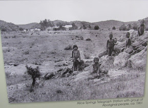
what would be known as Sydney. The white colonialists imposed their laws and customs on the native peoples who had lived on the continent for 60,000 years. These people subsequently lost their lands, which meant they lost their stories, their sense of the world, and their identity.
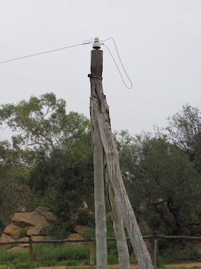
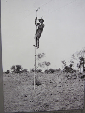
The Outback remained relatively free of the white colonialists until they decided to hook up their continent to England with the electric telegraph in 1871 near what would become Alice Springs. Other towns grew up along the Overland Telegraph Line and the Outback saw more and more white settlers displace the Aboriginal peoples in these vast, "empty" lands. Today, the Outback still remains pretty much "empty" because its climate is too extreme to endure and its water sources too scarce. Nevertheless, the "Red Center" attracts 250,000 tourists from all over the world each year. It turned out to be my favorite part of Australia because of its spiritual qualities. Deserts seem to speak to me, and I would not be disappointed at Uluru (formerly called Ayres Rock) or at Kata Tjuta (formerly called The Olgas).
Geological Formation Story
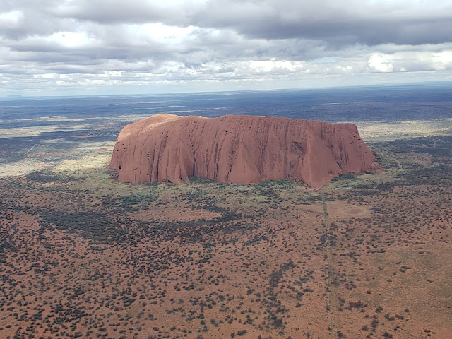
 Standing at 1,142 feet above the desert floor and almost 6 miles in circumference, Uluru is the world’s largest monolith and Australia’s most iconic landmark. Kata Tjuta rises nearly 1800 feet. The origins of these two rock formations date back about
500 million years during the same time the Australian continent was
formed as the Earth’s plates were shifting. Large crustal blocks merged together and rose from the sea. As a result,
Himalayan-sized mountain ranges formed. The rock formations that ultimately became Uluru and Kata Tjuta were in one of the mountain ranges called the Petermann Range, which was as high as today's French Alps. Only nubs of this range exist today because of a lack of plants or trees. After millions of years of rapid mountain building, erosion, flooding, folding, downward pushing, and more erosion, Uluru emerged as a monolith and Kata Tjuta as a conglomerate.
 Uluru is composed of sandstone, a sedimentary rock that eroded and washed downward from the big mountain ranges. And, what was formerly a horizontal layer of sand and gravel eventually flipped on its side and became hardened rock to form it present shape. The red color of the rock is due to the oxidation of the iron within the rock that has been exposed to the desert air for hundreds of
thousands of years. The rock is actually gray, which you can see in unexposed areas or if you rub the surface of the rock.

 For the Aboriginal people, the natural landmark was formed by ancestral
beings during the "Dreaming", the time of creation. Its numerous caves and fissures were due to the ancestral
beings' interactions. The Anangu people’s Dreaming story revolves
around 10 ancestral beings. For example, on the southern side of Uluru, the rock
structure was due to the war between the poisonous and carpet snakes.
The northwest side was created by Mala, the hare wallaby people.
Another area was formed by the Tjukurpa of Kuniya, the sand python, who
left her eggs a short distance away, and was dancing across the rock. To honor and show respect for the ancestors, the people held sacred ceremonies in certain caves and crevices. They also left ancient rock paintings to acknowledge these stories.
"Ownership" of Uluru
In 1872, European explorer Ernest Giles discovered the monolith and a year later William Gosse, a surveyor, named it Ayers Rock after the Chief Secretary of South Australia, Sir Henry Ayers. This name remained until October 26, 1985, when the Australian government returned ownership of Uluru to the Anangu people to show them respect and to acknowledge their original custodianship of the land. It arranged a 99-year lease where the land titles were in the Aborigines' names and the land was leased to the national parks.
In 1995, the name change officially took place when this area became known as Uluru-Kata Tjuta National Park. In this way, the native peoples have a voice in the management of the lands. Twelve people serve on the Board: 4 are white and 8 are brown or black elders. Of these 8 elders, 4 are males and 4 are females. Fires on the land are done in the traditional way but modified with some modern techniques. The Aboriginal people receive a percentage of ticket prices of park entrances. Meanwhile, UNESCO has named Uluru and Kata Tjuta a World Heritage site, one of 1,154 sites in the world.
Numerous trails weave around the base of Uluru with opportunities to learn about the Anangus' stories of the ancient rock paintings, caves, and crevices. Our bus took us around the circumference of Uluru with several stops at these significant places. The texts below are taken from signs like this one on the right to explain what the rock formations meant to the Anangus.

Tjukuritja (The Creation Story)
The story is in the rock and preserved for all time. Images of the rock formations and the accompanying text are designated by the numbers from right to left. The park's line drawing is accompanied by some photos.
1 -- Minyma Kuniya (woma python woman) arrives quickly after hearing her nephew has been speared by Liru (poisonous snake) warriors.
2 -- Kuniya changes into human form and creates inma (ceremony) to make inati (poison) to punish Wati Liru (poisonous snake man) for not looking after her injured nephew as he is culturally required to do. You can see the imprints where she drops to her knees, plants her kuturu (fighting club) in the ground and scoops up sand to throw over her body, protecting herself from the poison.
3 -- Kuniya moves towards Liru singing and dancing with akuta--a dance step women use when they want to fight. Liru has been made weak from the powerful irati and Kuniya hits him over the head. He falls down but gets back up.
4 -- Kuniya hits Liru a second time and finishes him off.
5 -- You can see Liru's eye is closed tight from the force of the blow.
6 -- Kuniya changes back into snake form and curls up on top of the art cave, her head resting on her python body watching over all who visit
The lesson of this story is that women should look after their children and that they have the right to defend them if necessary. Also, everyone needs to honor their responsibilities or be prepared to be punished appropriately.
Rock Art
The rock art at Uluru illustrates the way cultural knowledge and Tjukurpa stories were passed from generation to generation. The art has many layers of pictures, symbols and figures painted on top of each other because the same sites were used in Anangu education for tens of thousands of years. The rock surfaces acted like a classroom blackboard that a teacher used to teach a lesson, however, only those who attended the "class" could fully decipher the notes left behind.
It is difficult to accurately date the rock art at Uluru. Carbon dating can only pick up the age of the rock and the materials used for the pigments, rather than the paintings themselves. However, other evidence shows that people probably lived in this region for at least 30,000 years. The rock art is an important historical and scientific record of human occupation in this area.
 The Anangu
traditionally made their paints from natural minerals and ash. Dry
materials were placed on flat stones, crushed and mixed with kapi
(water) or animal fat. The most common paint colors were red,
yellow, orange, white, grey and black. These colors came from a variety
of materials. Tutu (red ochre) and untanu (yellow ochre) are
iron-stained clays that were very valuable and traded across the land.
Burnt kurkara (desert oak) provides both purku (black charcoal) and tjunpa/unu (white ash).
The Concept of Men's and Women's Business
In traditional Anangu
society, men and women have distinct but equally important roles,
performing specific tasks that benefit the whole community. This separation of responsibilities by gender is determined by Tjukurpa, the religious philosophy that links Anangu to the environment and their ancestors. It ensures a balance of work underpinned by a strong sense of cooperation. At the same time, men and women did not interfere with each other's business.
Women's Business -- Women were traditionally responsible for gathering water and bush foods such as fruits, seeds, vegetables, maku (edible grubs) and tjala (honey ants). They also hunted small food animals like tinka (goanna), ngintaka (perentie), kuniya (woma python), rapita (rabbit) and tjilkamata (echidna). Young girls went with their grandmothers, aunties, mothers and
older sisters to learn about preparing bush food, the seasonal cycles and habitats of
animals and plants, and how to use plants to create bush medicines. Girls learned about women's Tjukurpa and built on their knowledge and skills
throughout their lives. They also learned to craft and use women’s tools like the wana (digging stick), wira (coolamon), piti (bowl) and manguri
(head ring).
Men's Business -- Boys lived with their mothers and sisters until they were old enough to learn about men’s Tjukurpa. During this process, male Elders introduced them to secret ceremonies, songs, and men’s sacred sites. Young boys traveled across the country learning where the ancestral beings went and how they changed the country. They also learned how to find water, where to hunt for kuka (meat), and how to recognize the habits and tracks of the animals. They also learned how to make and use men’s tools and weapons and how to make fire and carry it from place to place.
Children had an important role to play in gathering and hunting. They accompanied their parents and other adults to collect bush food while they watched and learned.
There are also certain caves where men, women, and children went. However, there were
certain parts of Uluru that females could not look at and
parts that males could not look at. Below are a few of the caves and how they were used.
Mutitjulu (Family) Cave
For many generations Anangu families camped here. The men hunted for kuka (meat) and the women and children collected mai (bush foods). The food would be brought back here to share. At night around the campfire, generations of the people told stories, which taught the children about this place and paintings on the rock. Today, these stories are still told and handed down to the children.
Men's Cave
The Mala people came from the north and Uluru looked like a good place to stay for a while and make inma (ceremony). Inma began when men raised Ngaltawata (ceremonial pole).
In the senior Mala men's cave the men made their fires here and camped busily preparing for inma. They fixed their tools with malu pulku (kangaroo sinew) and kiti (spinifex resin). From here the men could keep an eye on the nyiinka (bush boys) in the cave around the corner and watch out for men coming back from a hunt with food.
STORY -- In the middle of preparations, two Wintalka men from the west approached and invited the Mala people to join the inma in their country. The Mala people said they could not because their ceremony had already begun and could not be stopped. The disappointed Wintalka men went back and told their people of the Malas' decision. They then summoned up an evil spirit, a uge devil-dog called Kurpany, to destroy the Mala inma. As Kurpany travelled towards Uluru he changed into many forms, from mikara (bark), to tjulpu (bird) and to different grasses. He was a manu, a ghost.
Luurnpa (kingfisher woman) was the first to spot Kurpany. She warned the Mala people but they didn't listen to her. When Kurpany arrived, he attacked the men in this cave. Some were killed and turned to stone. The remaining Mala people fled to the south with Kurpany chasing them.
The back wall depicts the old men's faces and white hair and beards. It is believed that their spirits are still here.
Women's Cave
This is the Kitchen Cave. Below is the Birthing Cave.
Teaching Cave
For many generations, Anangu elders taught nyiinka (bush boys) in this cave how to travel in this country and survive. Generations of grandfathers painted these pictures, like a teacher uses a blackboard, to teach nyiinka how to track and hunt kuka (food animals). Nyiinka would then be taken into the bush to learn about country like knowing where the waterholes were, where to find the animals, and where to source materials for their tools and weapons.
In the very beginning when the Mala ancestors arrived at Uluru, nyiinka camped here in this cave. A nyiinka is a boy at the important stage in life where he is ready to learn to become a wati (man). Nyiinka are taught by their grandfathers and separated from the rest of their families for this period. Traditionally, this stage lasted several years until a boy proved himself with hunting skills, self-reliance, and discipline. When they weren't out hunting, nyiinka stayed in this cave. This period has the same objective as high school: students learn a variety of skills and subjects to enable them to survive on their own as adults.
Callum (left) continues the teaching tradition by telling our group about the teaching cave.
Itjaritjariku Yuu
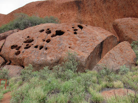
In the Tjukurpa (creation time), the ancestral Minyma Itjaritjari (marsupial mole woman) built this shelter and yuu (windbreak). The yuu is the large wedge-shaped stone at the opening to this cave. The holes in the rocks above the cave have been tunnelled out by Itjaritjari who have lived here since Creation and before the Mala people arrived.
Itjaritjari are very secretive. They spend much of their time underground and occasionally come out after a rain. They are blind, have soft, golden-colored fur, a backward facing pouch and are small enough to fit in your hand. Using their front paws like spades, they tunnel horizontally just under the surface in a swimming motion. They are unique creatures perfectly adapted to living underground in sandy deserts.
Mai Tjuta

People camped here at the Mutitjulo Waterhole for two or three days before moving on. This place supports tjuta (many) mai (bush food) plants. The people needed to know their mai really well before collecting it because some fruits were poisonous.
 Traditionally, the Aborigines were nomads who traveled all over the interior lands of Australia. They were constantly looking for food and water in their family groups. They would walk from Uluru to Kata Tjuta and back to Uluru, following the food and water. They would burn parts of the land as they traveled in order to encourage new mai to grow. People were healthy and strong, and so was their country.
Various Rock Formations
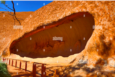
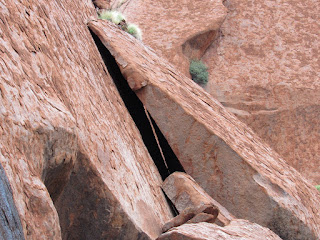
The stories in the rock and the Aborigines' uses of certain areas are one important thing a traveler learns about Uluru. Another is how the rocks are clearly a place for the imagination to wander and the heart and soul to open. Their shapes, especially those with holes and breaks in their red crusty surfaces fascinated me as well as those rounded clomps whose motion had been frozen in their tracks some time ago.


The energy of the rocks is still very much present. Mark, our bus driver (pictured in long blond hair and blue shirt) revealed that the spiritual energy of Uluru moves him to the point that when he puts his hands on the rock he cannot pull himself away. It's as if the rock holds him there.
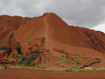
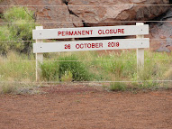
Climbing Uluru Now Forbidden
Sunset Toast to Uluru
Callum, our guide, provided appetizer treats with wine and champagne for our sunset toast to Uluru. Here I am as an enthusiastic participant in my new lavender Outback hat. Other tour groups were also there in this tourist bus-only setting. It was a nice touch to our tour after a long day of bus riding and a visit to Uluru.

Kata Tjuta -- The Olgas

Here is another photo from Steve's helicopter ride that dramatically brings out the geological and mystical qualities of Kata Tjuta as it mysteriously rises nearly 1800 feet from of the plateau that surrounds it. It has 36 domes over its 12 square miles and thousands of stories about man's relationship with nature and other men. While Uluru, the rock of Creation, was the women's rock, Kata Tjuta was the men's rock.
Kata Tjuta ("many heads") was renamed "The Olgas" by the British explorer Ernest Giles in 1872. He was first non-Aboriginal person to see Kata-Tjuta while leading a party near Kings Canyon in 1872. Giles named the largest dome Mount Olga, after Queen Olga of Württemberg.
Although not as famous or as imposing as Uluru, Kata Tjuta was no less powerful in its spiritual energy. Callum invited us to walk through this chasm, which at the time was cloaked in the morning's fog. And while Uluru stands like a Catholic church tabernacle where one gazes upon it in awe, Kata Tjuta beckons its visitors into its chasm daring them to be changed. Kata Tjuta was the walk of pilgrimage, and it would prove to be an unforgettable spiritual experience for me.
Geologically speaking, the rock here is finer and more sand-like than at Uluru and a example of conglomerate rock, which is a unique phenomenon at a huge scale here.
Although the rock looks smooth, its hard "flaky" crust makes the ground uneven and difficult to walk on, especially in the rain where slippage was all too easy. Yet, that is the nature of pilgrimage: there has to be some struggle in order to reach the Divine.
 I walked halfway through the chasm and before turning back because I was afraid of falling on the rocks. I pleaded with the rocks to give me a spiritual message--and they delivered.
The left side of the chasm with its black streaks and many holes attracted me. I stopped and faced it with my hands at my sides a few inches away from my body, and my palms out. I took some deep breaths and then it came. The holes in the rock represented my imperfections that had plagued me over a lifetime, many of them unconscious--until they surfaced during the two years of Covid isolation. I begged the rocks to release me from these bad memories, mistakes, slights, faults, errors, insults, and instances of disrespect that I had committed. Cleanse me, I asked the rocks. Heal me. Release me. I felt an energy beneath my feet. Then it came to me: the rock would take all those bad things and stuff them one by one into the holes. These faults would never disappear, but the rock would hold them for me and allow me to move on instead of ruminating on the past.
A man from home came to mind. He once told me: "God gave us a brain to figure things out". One of my fellow travelers said that this phrase was common Jewish wisdom. Wisdom was something I had prayed for in my early 30s because I thought it was the most efficient path to God. Little did I realize then that acquiring wisdom would take decades.
Then a woman passing by noticed my meditative stance and stopped to advise me to take off my shoes in order to be more connected to the Earth. She somehow recognized that I was experiencing an issue of the solar plexus, which is about confidence and control of one's life. I subsequently read that if the solar plexus is imbalanced, it leads to physical problems like overweight, over-eating, fatigue, stomach and digestion issues that can lead to acid reflex, hypoglycemia and/or diabetes. Balance of the solar plexus leads to self-confidence, happiness, joy, and personal power that prevents one from feeling desperate. Balance give a sense of belonging, a sense of knowing, peace and harmony with the self.
To help with the healing, one should gaze upon fire and yellow crystals; do aromatherapy, yoga, small acts of kindness, and deep breathing; say positive affirmations; surround oneself with yellow and gold colors; and eat yellow foods (lentils, bananas, peppers, pineapples, squash, grains).
So here I was in Australia at one of the world's great spiritual places, and I got these messages. I am truly blessed!
Resources
Photos by Steve S.
https://ulurutoursaustralia.com.au/blog/uluru-vs-ayers-rock-the-name-change-of-australia-s-most-iconic-monument/
https://www.abc.net.au/news/science/2017-06-27/how-did-uluru-and-kata-tjuta-form/8572068
https://ulurutoursaustralia.com.au/blog/the-significance-of-uluru-to-australian-indigenous-culture/
https://ulurutoursaustralia.com.au/attractions/uluru-kata-tjuta-cultural-centre/
https://parksaustralia.gov.au/uluru/discover/culture/mens-and-womens-business/
https://collections.museumsvictoria.com.au/articles/1862
https://parksaustralia.gov.au/uluru/do/rock-art/
https://parksaustralia.gov.au/uluru/discover/history/


